DULUTH, MN (KDAL) – Several rounds of thunderstorms with locally heavy rain are possible across the region over the next three days.
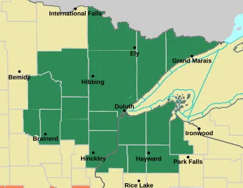
The National Weather Service Office in Duluth has issued a Flood Watch for northeast Minnesota and northwest Wisconsin from Tuesday evening through Thursday morning.
Heavy rain on top of already saturated soil from recent rainfall could lead to excessive runoff and flooding of rivers, creeks, streams and other low-lying flood prone locations.
The thunderstorms could also bring possible hail and damaging winds.
There is a good chance of at least an inch at most locations by Thursday but locally heavier amounts of three inches or more is possible.
The exact area of the heaviest rain is shifting so continue to monitor updated forecasts for the latest information.


Comments